The Pulse
The latest news about UrsaNav®

GPS/GNSS jamming and spoofing continue to increase around the world, affecting every mode of Positioning, Navigation, and Timing (PNT) – including aviation, maritime, land-mobile, handheld, and critical timing and frequency applications. The operational impacts are being felt most acutely across the aviation and maritime sectors, underscoring the growing need for resilient PNT solutions.
With aviation top of mind, several members of UrsaNav’s leadership team are attending the Farnborough International Airshow, July 20–24, including CEO & Founder Charles Schue, FRIN, FION; President Stephen Bartlett; and Chief Business Development Officer Erik Johannessen.
If you’ll be at Farnborough and would like to learn more about UrsaNav, eLoran, and the resilient PNT solutions we are deploying worldwide, we’d be delighted to meet with you.
To schedule a meeting during the show, please email info@ursanav.com.
We look forward to seeing you in Farnborough.
United in Loran
In the early 1940s, the UK and US worked on “Most Secret” and “Top Secret” programs that subsequently resulted in systems known as Loran. The UK efforts took place in and around Malvern, Worcestershire, and the US efforts were centered in and around Boston, Massachusetts. Eighty-six years later, these same two areas are at the forefront of developing the future of Loran.
QinetiQ UK’s current office in Malvern and UrsaNav’s office in North Billerica, MA, will now continue the long history of cooperation between the two regions: In the US, it was the MIT Radiation Laboratory (Rad Lab) and Harvard’s Radio Research Laboratory (RRL) that provided early work on Loran. In the UK, it was QinetiQ’s predecessors, the Telecommunications Research Establishment (TRE) and Air Defence Research and Development Establishment (ADRDE), that brought us GEE, the world’s first application of a hyperbolic navigation system. GEE then evolved over many decades to become eLoran.
Given all this history, it should come as no surprise that a team led by QinetiQ has recently secured a multimillion-pound contract from the UK Ministry of Defence (MOD) to create a deployable solution concept based on eLoran. Team Elaris—a name combining “eLoran” and “arise”—unites QinetiQ, UrsaNav, Roke, and GMV to deliver this new resilient positioning, navigation, and timing (PNT) concept for the UK MOD “Urgent Compass” programme.

Delivered over two years, the effort will lay the foundation for future demonstration, production, and large-scale deployment of eLoran-based systems designed for operations in contested and denied environments.
Modern military missions depend critically on reliable PNT. While global navigation satellite systems (GNSS) are often the backbone of these capabilities, these systems are increasingly vulnerable to jamming, spoofing, and meaconing by adversaries. In high-threat environments, compromised PNT signals can degrade operational effectiveness, disrupt coordination, and jeopardize mission success.
This programme directly addresses these challenges by advancing eLoran—a powerful terrestrial wireless alternative that delivers robust, independent PNT resilience when satellite signals are unavailable or unreliable. Designed with rapid deployment in mind, the solution will enable assured navigation and timing across a wide range of operational scenarios worldwide.
Bringing together deep technical expertise in resilient PNT, the team will evaluate both deployable and fixed eLoran architectures, ensuring flexibility across mission sets and geographies. The initiative represents a critical step toward strengthening layered PNT strategies and reducing dependence on vulnerable space-based systems.
*with a nod to J.R.R. Tolkien’s The Hobbit.
UrsaNav® will attend the Royal Institute of Navigation’s Annual General Meeting and Awards Ceremony on 01 July 2026 at the Royal Geographical Society in London, England. Representing UrsaNav at the event will be Dr. Paul Williams, a recognized expert on the propagation of Loran signals over land, including in irregular terrain, and in the development of ASFs.
We look forward to engaging with fellow leaders in navigation and sovereign communications as we continue to support assured PNT initiatives in the UK and beyond.

Is the Shipping Industry Missing the Boat on Resilient PNT?
The Suez Canal is one of the world’s most strategically important maritime choke points. Approximately 12% of global trade passes through a waterway that, in some locations, narrows to only a few hundred meters across.
At the same time, the region has experienced repeated and well-documented Global Navigation Satellite System (GNSS) disruption events.
Examples include:
- In 2019, the U.S. Maritime Administration issued warnings regarding significant GPS interference affecting vessels near Port Said and the Suez Canal approaches.
- In April 2024, more than 100 vessels simultaneously reported false positions due to spoofing activity.
- Since 2023, maritime and aviation operators across the Eastern Mediterranean and Egypt have reported persistent GNSS degradation and interference.
Importantly, these events are not necessarily criminal in origin. In many cases, they are the byproduct of state-level electronic warfare activity associated with air defense operations, counter-unmanned aircraft system systems (UAS), and intelligence, surveillance, and reconnaissance (ISR)-denial capabilities.
The result is an increasingly contested navigation environment where positioning data can be degraded, denied, or — perhaps most dangerously — silently corrupted.
The operational implications for the Suez Canal are significant.
The Canal is a highly constrained transit environment characterized by:
- dense vessel traffic,
- limited maneuvering space,
- strict traffic management,
- and extremely low tolerance for navigation error.
In this context, even small positioning inaccuracies can become operationally consequential.
Between 2013 and 2016, UrsaNav worked with the General Lighthouse Authorities of the UK and Ireland (GLAs) to implement and trial differential Loran capabilities at seven locations along the eastern coasts of England and Scotland.
Differential Loran is a critical component of modern eLoran systems supporting harbor entrance and approach (HEA) operations.
Published GLA trial results documented measured horizontal positioning accuracy of approximately seven meters (95%), well within the International Maritime Organization’s 10-meter HEA requirement. These performance levels were maintained at distances of at least 40 kilometers from the differential reference stations.
The implications for maritime choke points such as the Suez Canal are substantial.
Historically, Loran systems have already been successfully deployed in similar environments. In the early 1980s, Loran service was implemented along the Suez Canal and became an integral component of the Canal’s Vessel Traffic Management System (VTMS) before eventually being displaced by GPS adoption.
Modern eLoran could once again provide a terrestrial layer of resilient, co-primary positioning, navigation, and timing (PNT) architecture capable of maintaining continuity of operations during GNSS disruption events.
This concept is not new.
In 2003, the Royal Institute of Navigation’s Journal of Navigation proposed the Suez Canal Integrated Navigation System (SCINS), envisioning a resilient navigation architecture combining terrestrial and satellite-based capabilities.
A modernized implementation could provide:
- assured positioning during GNSS disruption,
- increased operational resilience,
- improved vessel traffic continuity,
- and, potentially, greater flexibility than today’s convoy-based transit model.
The broader implications extend well beyond the Suez Canal.
Resilient terrestrial PNT capabilities would strengthen navigation assurance across:
- major shipping lanes,
- ports and harbors,
- offshore energy operations,
- narrow straits,
- and heavily congested maritime corridors such as the English Channel.
The maritime industry has already seen how deeply bridge systems depend on GNSS availability.
During GPS jamming trials conducted by the GLAs in 2008 and 2009 aboard the NLV Pole Star and THV Galatea, disruption effects were observed across numerous shipboard systems, including:
- automatic identification system (AIS),
- radar,
- gyrocompass systems,
- electronic chart display and information system (ECDIS),
- digital selective calling (DSC),
- voyage data recorders,
- and dynamic positioning systems.
Modern maritime trade has been built on the assumption that GNSS is continuously available and inherently trustworthy.
That assumption no longer holds — particularly in contested regions and strategic maritime corridors.
As Captains Matt Shirley and Dana A. Goward recently noted in When GPS Fails: Why Maritime Needs Resilient Navigation, published by Hellenic Shipping News Worldwide, GNSS disruption is no longer hypothetical. It is an operational reality affecting shipping activity in regions that include the Persian Gulf, Baltic Sea, and Eastern Mediterranean.
Resilient PNT is therefore no longer optional.
Multi-constellation GNSS improves capability, but it does not eliminate systemic vulnerability. Interference awareness must become operational rather than theoretical, and independent PNT sources must be integrated into both shipboard bridge systems and shore-based traffic management architectures.
Because when GNSS degrades, the industry does not simply lose precision.
It loses trust, operational continuity, efficiency, and, ultimately, money.
And those costs are carried by shipowners, operators, insurers, ports, supply chains, and consumers worldwide.

Loran has included tactical applications since the 1960s. Early examples included U.S. deployment of manned, air-deployable transmission sites in Southeast Asia. These systems relied on fixed antenna structures to achieve the required wide-area coverage. Other programs adapted “antennas of opportunity,” including legacy radio beacon, AM broadcast, and very low frequency (VLF) infrastructure. The Anthorn, UK site, for example, uses a “Tee” antenna suspended between two masts originally built for a VLF system. The U.S. Department of Defense (DoD) also fielded deployable concepts using tethered aerostats, while some projects employed quick-erect masts for shorter-range missions.
From the beginning, tactical Loran systems reflected a balance between coverage, portability, infrastructure, and mission requirements.
The Evolution from Fixed Systems to T3
Early Loran systems were large, fixed installations by necessity, designed to meet demanding technical performance requirements. Advances in transmitter, antenna, and control technologies gradually enabled smaller, more portable solutions with advantages for specific operational needs. These developments led to modern tactical, temporary, and transportable (T3) systems.
Today, both fixed and deployable systems remain relevant because they solve different problems and can perform well with different inputs.
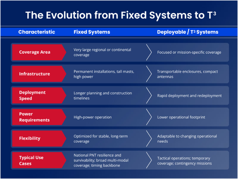
Several nations are evaluating a mixed approach: fixed systems for broad regional coverage, deployable systems for targeted operational needs, and combinations of both where mission requirements demand flexibility.
Experience Across the T3 Spectrum
Our personnel have worked with several T3 Loran and eLoran systems over the years.
We supported, and later replaced, the Air Transportable Loran System (ATLS) at the former Loran-C transmission site in Lampedusa, Italy. We worked with the U.S. Air Force tactical Loran-D system, which included configurations that used tri-tethered aerostats to elevate transmit antennas. We served as a subcontractor on the triple-CONEX box solution currently deployed at the Anthorn, UK eLoran site.
We also designed, developed, deployed, and operationally tested a prototype T3 solution for the U.S. Army, and contributed to two “mini-chain” Loran-C implementations: one along the Saint Lawrence Seaway and another supporting the Suez Canal region.
Our current T3 transmission system combines a transportable transmitter, eLoran signal generation, monitoring, and control capability with a purpose-built transmit antenna. The system has been deployed and redeployed in Canada, multiple U.S. locations, and Germany.
A Practical Example: Fixed and T3 Working Together
A hybrid architecture can provide compelling operational benefits.
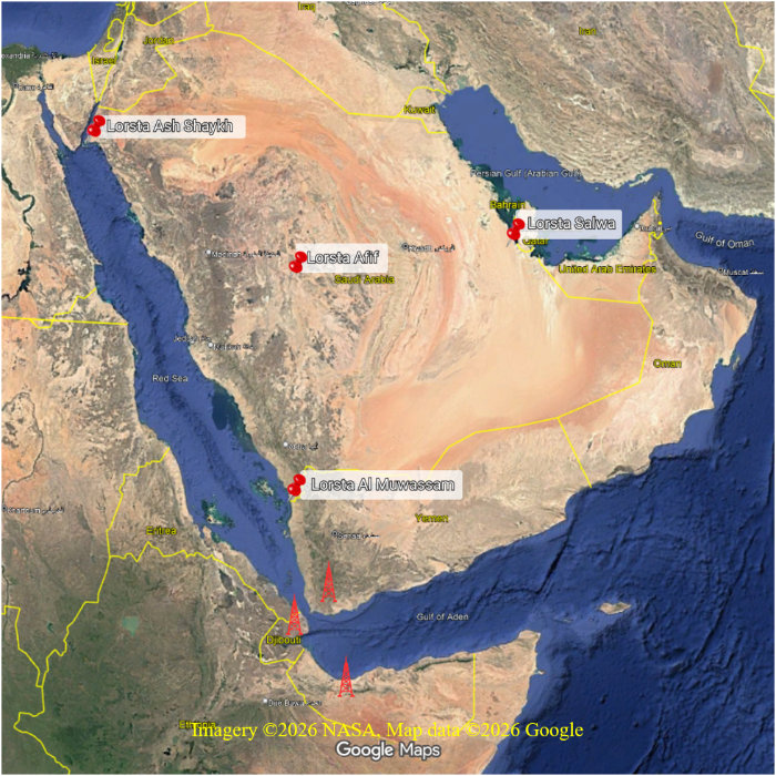
Consider the Middle East. The Kingdom of Saudi Arabia operates eLoran transmission sites at Afif, Salwa, Ash Shaykh Humayd, and Al Muwassam. Complementing this fixed infrastructure with representative T3 deployments in the Red Sea and Gulf of Aden region could extend high-quality positioning coverage through the Gulf of Aden, across the Bab el-Mandeb Strait, and into the Red Sea.
Deployable sites in locations such as Djibouti, Yemen, and Somalia could provide positioning accuracies better than 10 meters in key operational areas. At the same time, users could benefit from reception of high-power signals from fixed Saudi sites, particularly Al Muwassam and potentially more distant transmitters such as Salwa and Afif.
This example illustrates an important point: Fixed and deployable systems are not competing solutions. In many environments, they are complementary capabilities.
Build the Right eLoran Architecture for Your Mission
There is no universal answer to PNT resilience. The optimal architecture depends on geography, operational objectives, coverage requirements, deployment timelines, infrastructure constraints, and long-term sustainability considerations.
Whether your use case calls for fixed infrastructure, a deployable T3 capability, or a hybrid approach, selecting the right technology strategy matters.
UrsaNav has experience across the full spectrum of Loran and eLoran implementations, ranging from legacy tactical systems to modern T3 solutions. If you are assessing resilient PNT options, consult with our team to identify the technology and architecture best aligned with your operational requirements. Contact us at Info@UrsaNav.com.
Should National Critical Infrastructure Depend on PNT Solutions Outside National Control?
Discussions surrounding alternative, complementary, and backup Positioning, Navigation, and Timing (PNT) systems often begin with a single assumption: global coverage is the primary objective.
For critical national infrastructure, that assumption deserves reconsideration.
For energy grids, telecommunications, transportation systems, emergency services, financial networks, and defense operations, sovereign coverage may be equally — if not more — important than global reach. National resilience begins with trusted infrastructure under national control.
At the same time, interference against Global Navigation Satellite Systems (GNSS) continues to increase worldwide. Jamming, spoofing, and meaconing events are now routinely observed in contested regions and near strategic infrastructure.
Importantly, space-based alternatives are not immune to disruption. Low Earth Orbit (LEO) systems remain vulnerable to interference affecting both uplink and downlink communications. Recent disruptions to commercial satellite services in the Middle East have demonstrated the operational realities of this threat environment.
Historically, terrestrial PNT systems played a foundational role in resilient navigation and timing.
While the Transit (NAVSAT) system introduced accurate satellite-based global navigation capability, it did not initially provide continuous real-time positioning and was primarily intended for military applications. Earlier terrestrial systems such as Decca Navigator and Loran provided highly effective regional navigation services, while Omega later became the first globally available continuous terrestrial PNT system accessible to civilian users.
Notably, all major PNT architectures — including modern GNSS constellations — rely on extensive ground infrastructure and international coordination to function effectively.
This highlights several strategic realities:
• There is no “global” PNT capability without terrestrial infrastructure.
• There is no globally available service without international cooperation.
• There is no space-based PNT capability without communications dependencies.
A sovereign terrestrial PNT architecture directly addresses these dependencies.
In a sovereign eLoran deployment:
• the ground segment remains entirely within national borders,
• communications infrastructure is nationally owned and controlled,
• reliance on foreign or commercial space-based assets is minimized,
• and the system can be hardened against both physical and cyber threats.
Spectrum coordination may still require international cooperation, but operational control remains national.
Equally important, terrestrial systems avoid many of the cost, launch, sustainment, and lifecycle complexities associated with space-based architectures.
When GNSS signals are available and trustworthy, they should remain at the forefront of modern PNT solutions. However, resilience requires trusted alternatives when those signals become unavailable, degraded, or compromised.
This is where eLoran becomes strategically significant.
As part of a layered “system of systems” architecture, eLoran provides the resilient terrestrial foundation for sovereign PNT capability — supporting national resilience, infrastructure continuity, and operational assurance in contested environments.
In an era of increasing dependence on precise timing and positioning, sovereign terrestrial PNT is no longer simply a backup capability.
It is strategic infrastructure.

UrsaNav®’s Chief Business Development Officer, Erik Johannessen, will be a featured speaker at the European Navigation Conference (ENC) in Vienna, taking place 28–30 April 2026. Dr. Philip Mattos will also be in attendance.
Erik will present in Session S3.3 (eLoran) on Wednesday, 29 April.
If you are attending and interested in the future of secure and resilient positioning, navigation, and timing (PNT) technologies, we invite you to join his session or reach out to schedule a meeting.

UrsaNav® CEO and Founder Charles Schue, FRIN, FION will attend the 2026 Resilient Navigation and Timing Foundation Annual Meeting in Washington, D.C. UrsaNav is a co-sponsor for the event.
If you are attending and would like to schedule a meeting with Chuck, feel free to contact him through LinkedIn.

Heading to the Defense Strategies Institute 6th Annual Assured PNT Summit on April 7–8 in Washington, D.C.?
UrsaNav® Chief Business Development Officer Erik Johannessen will be there connecting with customers, industry peers, and new partners across the positioning, navigation, and timing (PNT) community.
If you are curious about enhanced Long-Range Navigation (eLoran) and the work we do, message us through LinkedIn to schedule a time with Erik and learn more about the resilient PNT solutions we deliver worldwide.

We’re proud to share that Charles Schue, FRIN, FION, CEO and founder of UrsaNav®, will be presenting “Loran, or ‘There and Back Again’” at the Radio Club of America (RCA) Technical Symposium on November 22, 2025, in Washington, DC.